Three Pacific hurricanes are active, while a fourth system may develop near Mexico. See the latest storm locations, wind speeds and Hawaii impacts.
Pacific Hurricanes Keep Forecasters on Alert
Three hurricanes are spinning across the Pacific Ocean, while another tropical system near southwestern Mexico could strengthen into a named storm.
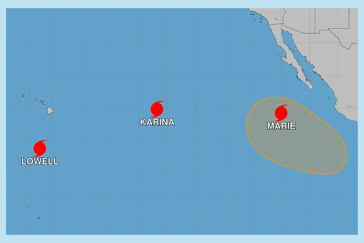
Hurricanes Karina, Lowell, and Marie were active Saturday, September 5, 2026. The unusual pattern marks the first time in more than a decade that three Pacific hurricanes have been active simultaneously.
Forecasters are watching Hurricane Lowell most closely because of its strength and the possibility of dangerous surf and rip currents affecting Hawaii.
Why Three Hurricanes at Once Is Unusual
The current Pacific setup is the first triple-hurricane stretch since 2015, when Hurricanes Kilo, Ignacio, and Jimena all reached major hurricane strength.
This season’s activity has been linked to El Niño conditions. The climate pattern can increase storm development in the Pacific while suppressing hurricane activity in parts of the Atlantic, including the Caribbean.
Scientists also expect the current El Niño to become exceptionally strong, which could continue influencing tropical weather patterns in the coming months.
Hurricane Karina Is Weakening
Hurricane Karina had declined to a Category 1 storm by Saturday morning. The National Hurricane Center expected the system to weaken quickly and dissipate by early the following week.
At that time:
- Karina was about 800 miles east of Hilo, Hawaii.
- Maximum sustained winds were 75 mph.
- The storm was moving northwest at 8 mph.
Forecasters reported no land hazards associated with Karina. The storm was expected to remain over open water as it weakened.
Hurricane Lowell Remains the Main Threat
Hurricane Lowell was the strongest storm in the Pacific on Saturday. It was a Category 4 hurricane with maximum sustained winds of 150 mph.
The storm was located approximately 630 miles southwest of Lihue, Hawaii, and was moving west at 7 mph. Forecasters expected Lowell to remain a major hurricane for several days, although some changes in strength were possible.
Tropical Storm Watches Could Be Issued
The National Hurricane Center said tropical storm watches could be needed for parts of the western Hawaiian Islands and the Papahānaumokuākea Marine National Monument.
The forecast track showed Lowell moving across portions of the marine monument Monday night. The system was also generating swells that were spreading north toward the Hawaiian Islands.
Those swells could produce:
- Dangerous surf
- Strong rip currents
- Hazardous conditions for swimmers and surfers
- Difficult conditions for small boats
Residents and visitors should rely on official local advisories because hurricane tracks and intensity forecasts can change quickly.
Hurricane Marie Is Also Losing Strength
Hurricane Marie was a Category 1 storm on Saturday and was expected to weaken over the next several days.
The storm’s position and conditions were:
- About 675 miles west of the southern tip of Baja California
- Maximum sustained winds of 90 mph
- Moving northwest at 9 mph
Marie was not forecast to make landfall. Its expected weakening trajectory would keep the system away from immediate coastal threats, although marine conditions could still be affected along its path.
Fourth System Could Become Tropical Storm Norbert
The National Hurricane Center was also monitoring a fourth disturbance far offshore of southwestern Mexico.
Forecasters gave the system a 60% chance of developing into a tropical depression later in the week. It was moving west-northwest at approximately 10 to 15 mph.
If the system strengthens enough to receive a name, it would become Norbert, the next name on the eastern Pacific storm list.
At the time of the forecast, the disturbance posed no immediate threat to land. Its development will depend on whether it can organize over warm ocean water and maintain a defined circulation.
What Hawaii and Mexico Should Watch
Hawaii’s most significant concern is Hurricane Lowell, particularly because of the storm’s size, strength, and ability to generate large swells. Even when a hurricane does not make landfall, distant waves can create dangerous coastal conditions.
Karina and Marie were expected to weaken, while the fourth system near Mexico remained under observation. The latest Pacific hurricanes forecast showed no immediate direct threat from those three systems, but conditions can change rapidly in tropical weather.
Residents should monitor updates from the National Hurricane Center, local emergency officials, and the National Weather Service before making decisions about travel, boating, or beach activities.